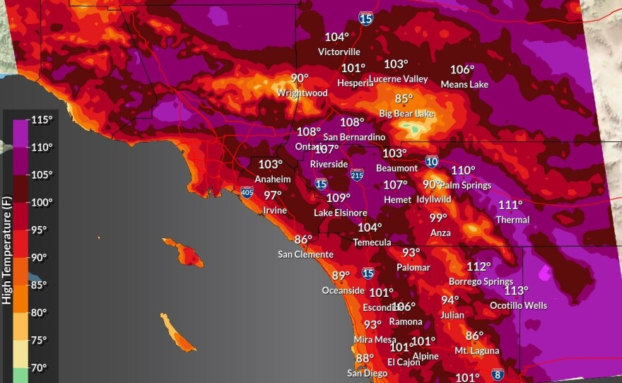
Scorching temperatures, which are setting new records daily, continued Monday across much of San Diego County with an excessive heat warning in place until Friday night.
Some drying with mid-level flow strengthening is expected to lead to increasing high temperatures through Monday, which is expected to be the hottest day of the week for most areas.
On Monday, the National Weather Service extended the excessive heat warning that has been in effect all weekend, which is now set to expire at 8 p.m. Friday.
The expected high heat led the San Diego Padres to announce it would be offering complimentary cold bottled water to ticketed fans — while supplies last — at the Labor Day afternoon game against the Arizona Diamondbacks. Fans can also pick up free sunscreen at aid stations throughout Petco Park.
At another Labor Day weekend sporting event during the heat wave, several attendees of Saturday's first-ever football game at Snapdragon Stadium were treated for heat-related illnesses as temperatures reached triple digits.
On Sunday, Escondido set a record of 102 degrees for the hottest temperature on this day, breaking a 1997 record of 101, according to the National Weather Service.
Oceanside Harbor set a record of 95 degrees for highest maximum temperature on this day, breaking the 1961 record of 90. And the 102 degrees in Ramona tied its record set in 2010.
San Diego's high temperature of 95 on Saturday broke the 1998 record high of 92 degrees, while Chula Vista's high of 96 broke the 1955 record high of 94.
The highs were expected to weaken by the middle of the week with cooler temperatures slowly spreading inland. High temperatures are expected to return to closer to average by the end of the week, according to the weather service.
The east flow was predicted to weaken substantially on Tuesday, allowing the sea breeze to offer some cooling for the coastal areas and western valleys, though the mountains and deserts won't see much change.
Another burst of east winds may cause areas west of the mountains to heat up a bit again Wednesday while remaining areas won't change much.
The excessive heat warning may need to be extended into Wednesday for some areas west of the mountains, NWS officials said.
The ridge should finally weaken Thursday and Friday for significant cooling with temperatures gradually returning to near normal. No hazardous marine weather was expected through Wednesday.


