Great pic of Ocean Beach Pier shot by @10News viewer Karen Wilson-Bonnar just a few minutes ago. #sdweather #10news pic.twitter.com/i3SO0QSaxW
— Preston Phillips (@10NewsPhillips) March 2, 2014UPDATE: 5:24 p.m.: High Surf, Strong Winds Expected To Close Ocean Beach Pier
The large waves brought on by the Pacific storm raining down on San Diego may close the Ocean Beach Pier, NBC 7 reports:
San Diego lifeguards were expected to close the Ocean Beach Pier, beginning at 5:30 p.m. Lifeguard Marine Safety Lt. John Sandmeyer said concerns over high surf, high tides and high swells factored into the decision.
UPDATE: 4:42 p.m.: Brace Yourself, Coastal Areas
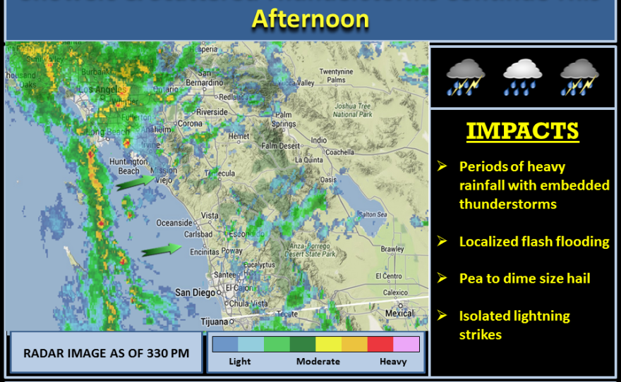
National Weather Service warns of thunderstorms heading to San Diego's coasts:
A line of fast moving thunderstorms heading towards the #SanDiegoCountyCoast will produce brief heavy showers, gusty winds, & flooding.
UPDATE: 4:01 p.m.: Closed Roads, Flooded Streets — And It Could Keep Coming
After dumping 5 inches of rain on parts of San Diego County and wreaking havoc on its roadways, the winter storm is expected to let up a bit, but rain showers and scattered thunderstorms could continue through the rest of the weekend.
According to the National Weather Service:
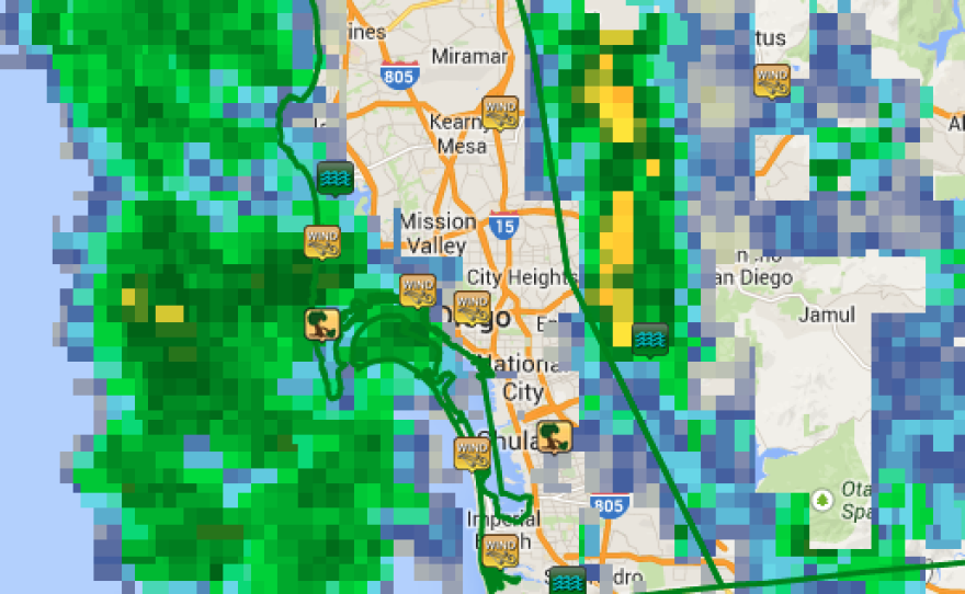
Latest radar echoes show that heavy showers and thunderstorms off the coast are advancing east and northeast and will move over the entire region through this evening. These storms will contain small hail and strong gusty winds.
Roadway flooding was reported on:
- I-5 N at Sea World Drive;
- I-15 S at the Citracado Parkway off-ramp and;
- SR-163 N near the eastbound Friars Road exit.
The showers also brought some rainy-day pile-ups on local roadways. From the California Highway Patrol, crashes on freeways and in unincorporated areas in San Diego County and Temecula:
- Midnight-2 p.m., Sat.: 212 crashes;
- Midnight-9 p.m., Fri: 541 crashes.
- Fair weather avg: 50-75 crashes
UPDATE: 3:50 p.m.: Flooding Closes Some County Roads
The San Diego County Of Public Works posted this update:
De luz murrieta is now closed at the de luz split and riverside county line.
Also De Luz is closed at the De Luz murrieta split other side is inaccessible.
A high surf advisory is in effect through Monday.


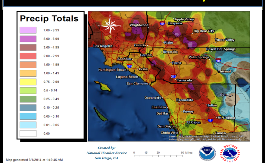
UPDATE: 3:17 p.m.: NWS Releases Total Rainfall From Two-Day Storm
Preliminary two-day rainfall totals as of 2 p.m.:
UPDATE: 1:10 p.m.: 'Widespread' Showers, Thunderstorms To Increase Flash Flood Threat

As the low pressure system passes over San Diego's inland areas, "shower and thunderstorm activity will become more widespread" through Saturday afternoon and evening, according to the National Weather Service.
The agency said this will increase the chances of flash flooding:
High intensity rainfall from showers and isolated thunderstorms on top of newly saturated soil will continue to flash flooding threat through late tonight.
A flash flood watch remains in effect for San Diego coastal areas, valleys and mountains.
Costal mountain slopes, regions near and downstream of recent burn areas and low lying areas with poor drainage are most likely to experience flash flooding.
You can view reports of flooding and damage using the NWS's interactive map.
UPDATE: 10:58 a.m.: Low Pressure Brews Off Coast; Will Hit SoCal Tonight

Strong low pressure off the central California coast will move inland across SoCal through tonight. Latest IR image shows a large area of heavy showers and strong thunderstorms just off the coast. Some of these storms will contain small hail and gusty winds.
UPDATE: 10:38 a.m.: Street Flooding In North County
An urban and small stream flood advisory extended to northwestern San Diego County until 11:45 a.m.
According to the National Weather Service:
"Brief heavy rainfall is causing some street flooding problems... rapid rise of small streams and drainage ditches."
Impacted areas include:
- Bonsall
- Camp Pendleton
- Carlsbad
- Fallbrook
- Oceanside
- Rainbow
- San Clemente
- Temecula
- Vista
Scattered thunderstorms moving inland across #OrangeCounty and northern #SanDiegoCounty are producing brief heavy rain and pea size hail.
— NWS San Diego (@NWSSanDiego) March 1, 2014UPDATE: 8:22 a.m.: Heavy Rains, Hail Possible For San Clemente, Del Mar
Coming off heavy rains from the day before, the National Weather Service is warning that the winter storm is not over for San Diego:
Scattered thunderstorms moving inland across #OrangeCounty and northern #SanDiegoCounty are producing brief heavy rain and pea size hail.
The agency earlier said the "line of thunderstorms" was headed toward the coast from San Clemente to Del Mar.

A powerful Pacific storm buffeted the San Diego area Friday with heavy rain and stiff winds, vexing motorists in particularly drenched areas while delivering a healthy dose of moisture to the parched region.
As of early evening, the downpours had forced scattered minor mudslides and road closures across the county but had caused no reported significant damage. Precipitation amounts by then ranged from less than one-tenth of an inch along the coast to more than five inches inland, according to the National Weather Service.
Recorded Rainfall Across San Diego County (in inches):
5.12 at Palomar Observatory;
4.33 in Birch Hill;
3.28 at Henshaw Dam;
2.83 in Oak Grove;
2.68 in Valley Center;
2.22 in Julian;
2.05 on Volcan Mountain;
1.96 at Lake Cuyamaca;
1.94 in Santa Ysabel;
1.81 in Barona;
1.74 at Lake Wohlford and in Warner Springs;
1.66 on Mount Laguna;
1.29 on Otay Mountain;
1.15 in Descanso;
Farther west:
1.86 at Ramona Airport;
1.81 in Fallbrook;
1.66 in Bonsall;
1.61 in Escondido;
1.43 in Oceanside;
1.09 in Rancho Bernardo;
1.05 in Poway;
0.9 in La Mesa;
0.84 in Carlsbad;
0.82 in Flinn Springs;
0.77 at Montgomery Field;
0.67 in Mission Valley;
0.62 in Solana Beach;
0.53 at Lindbergh Field;
0.49 at Brown Field;
0.36 in Harbison Canyon.
The showers -- a definite local rarity in recent months -- ushered in some all-too-familiar rainy-day headaches on local commuter routes.
Between midnight and noon, the California Highway Patrol logged 236 accidents, as compared with the 50-75 the agency generally handles over a full day of fair weather. The wrecks led to widespread congestion but resulted in no reports of serious injuries.
Showers and strong winds were expected to continue through the weekend. Some slushy snow was likely to accumulate on the county's highest peaks late Friday and early Saturday morning, NWS meteorologist Alex Tardy said.
To help residents and merchants deal with the storm, the San Diego Fire-Rescue Department distributed sandbags at fire stations in Ocean Beach, the Midway area, Pacific Beach, Kearny Mesa, San Ysidro, Rancho Bernardo, Scripps Ranch, Tierrasanta, Rancho Penasquitos, Santa Luz and Pacific Highlands.
The empty sacks also were made available at lifeguard stations in Ocean Beach, Mission Beach, La Jolla Shores and Pacific Beach, with users responsible for filling them, using beach sand if so desired.
The rain wiped out all the matches at the 125th annual Pacific Coast Men's Doubles Championship at the La Jolla Beach & Tennis Club. Play is scheduled to resume at 8 a.m. Saturday.


