Large groundwater withdrawals are causing land in California's Central Valley to sink. It's become so serious that it’s threatening flood control and water deliveries. The proposed high-speed rail system will also have deal with the changing terrain.
Chase Hurley is general manager of the San Luis Canal Company in Dos Palos. He points to a small dam near the river in western Madera County. It’s likely the most important structure for the irrigation company because it guides water from the river into its canal system.
“That dam, and this canal are sinking roughly 6 inches a year," Hurley said. "So when that happens the dams not going to be high enough to physically gravitational push that down the canal.”
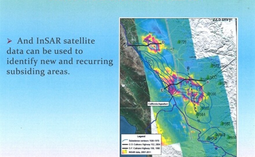
Groundwater withdrawals in the Central Valley are causing the ground to sink. It’s a phenomenon called subsidence, and historically it’s been a problem in the Central Valley. But satellite maps show the problem is much worse.
“We’ve got some recent information from NASA and some staff at the Jet Propulsion Laboratory and have noticed two areas that are subsiding nearly up to a foot a year for the past four to five years,” said Dane Mathis, an engineering geologist with the California Department of Water Resources.

The rate of subsidence varies geographically, but it covers a large area across western Madera and Merced counties. And going right through it, is the San Jose to Merced segment of California’s proposed high-speed rail system.
“We’re aware of it, we take that into consideration as another engineering element to take into our design elements,” said Frank Vacca who is in charge of engineering teams for the California High Speed Rail Authority.
He said the High Speed Rail will use ballasted track comprised of stone, which he said is flexible enough for subsidence.
“If you have to adjust it you can add more stone and quickly bring it back to the level you require it at, so it makes it very economical to adjust the track,” Vacca said.
But other engineers claim there are a lot of variables.
Bruce Kutter, a civil engineering professor at UC Davis, said the integrity of the rail bed will depend on the severity of the subsidence and how rapidly it occurs along the track.

“Over a short distance if there’s a significant change in the elevation of the track, the ride will become uncomfortable and bumpy and potentially unsafe,” Kutter said.
If the subsidence is gradual over the length of the track, Kutter said it would be manageable.
In some areas, the rate of subsidence is causing alarm.
"In the last five years there’s been subsidence of four feet," said Reggie Hill, with the Lower San Joaquin Levee District, which operates the Eastside Bypass.
"Our bypass system is right in the middle of it," he said. "We convey flood flows around the San Joaquin River because the San Joaquin River has constraints in its channel, and the bypass system is designed to carry twice the amount that the river can."
But when channels sink, river banks erode. The loosened soil moves downstream, reducing capacity and pushing water close to the top of 14 miles of levees.
“It’s an extreme situation," Hill said. "We need to address it and now that we’re aware of it we need to jump on it as quickly as we possibly can.”
Subsidence is putting hundreds of acres of farmland, an elementary school, the city of Dos Palos and state Highway 152 at risk.
Michelle Sneed, a USGS hydrologist said subsidence is causing even more problems.
About 50 feet away from the Delta Mendota Canal, just south of a small town called Oro Loma in the Central Valley, Sneed measures groundwater levels.
The Delta Mendota Canal carries water to parts of the central valley and southern California.

“In this location there are several visual effects that you can see as a result of subsidence," Sneed said. "A couple of them are buckles in the lining of the canal."
Sneed’s been studying the effects of subsidence on the Delta Mendota Canal for several years.
“It’s not a small problem," she said. "It’s a problem for not only the Delta Mendota Authority and the Bureau of Reclamation to maintain the flow and level in the Delta Mendota Canal but there are canals that are just snaking through this area.”
One canal just a few miles north has lost 50 percent of its capacity due to subsidence.
A USGS study soon to be released will show the details and the extent of the subsidence problem, and how it’s reducing capacity of the Delta-Mendota Canal, the California Aqueduct, and other canals that carry water to both urban and agricultural areas.


