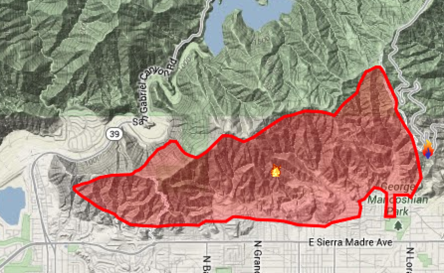
GLENDORA, Calif. — A wildfire in the suburbs of Los Angeles was a smoldering shadow of its former self, but hundreds of residents of a foothill neighborhood remained evacuated and extremely dangerous fire conditions were expected to last well into Saturday.
Another wave of evacuees returned Friday evening to their homes, this time in Azusa, 25 miles northeast of downtown Los Angeles, a day after their neighbors in Glendora did the same. But one Azusa neighborhood known as Mountain Cove remained too close to the remaining fire, so its residents would have to spend another night away, Los Angeles County emergency officials said.
Compare Colby Fire Satellite Photos
View the difference between two photos captured the morning the Colby Fire began and later that afternoon.
Flare-ups occurred within the burn area of about 3 square miles but none escaped the perimeter, said Mike Wakowski, commander of the multi-agency firefighting force. Containment was estimated at 30 percent.
"Things are progressing nicely," Wakowski said. "It's looking pretty good."
Crews took advantage of the lower temperatures and wind conditions overnight to set backfires to take out potential fuel for the blaze, and continued Saturday to mop up.
The fire erupted early Thursday in the Angeles National Forest when Santa Ana winds hit a campfire that authorities said was recklessly set by three men. Gusts quickly spread flames from the San Gabriel Mountains into Glendora and Azusa, where some 3,700 people had to evacuate at the fire's peak.
Five homes were destroyed and 17 other houses, garages and other structures were damaged, according to early assessments.
Red-flag warnings of critical danger due to the combination of winds, extremely low humidity and extraordinarily dry vegetation were repeatedly extended during the week. The National Weather Service said some warnings would expire Friday evening but others would remain for mountain areas until 6 p.m. Saturday.
"The conditions are still extreme out there," said Tom Contreras, supervisor of the Angeles National Forest.
The state is in a period of extended dry weather compounded in Southern California by repeated periods of the regional Santa Anas, dry and powerful winds that blow from the interior toward the coast, pushing back the normal flow of moist ocean air and raising temperatures to summerlike levels.
The dry conditions statewide led Gov. Jerry Brown to formally declare a drought Friday in order to seek a range of federal assistance.


